Vulnerability methods in hard rock formation as a basis for groundwater risk assessment – from resource to source
Article Sidebar
Main Article Content
Abstract
Groundwater in a hard rock formation is most endangered at places where a potential source can discharge contaminants that can reach the saturated zone of an aquifer. In these circumstances, an essential tool for groundwater protection is the contamination risk map. This map is based on the integration of two maps: a hazards map, i.e., map of potential sources of contamination and a vulnerability map. The selection of a proper vulnerability method is an important task since the resulting vulnerability map can significantly impact the final risk of contamination map.
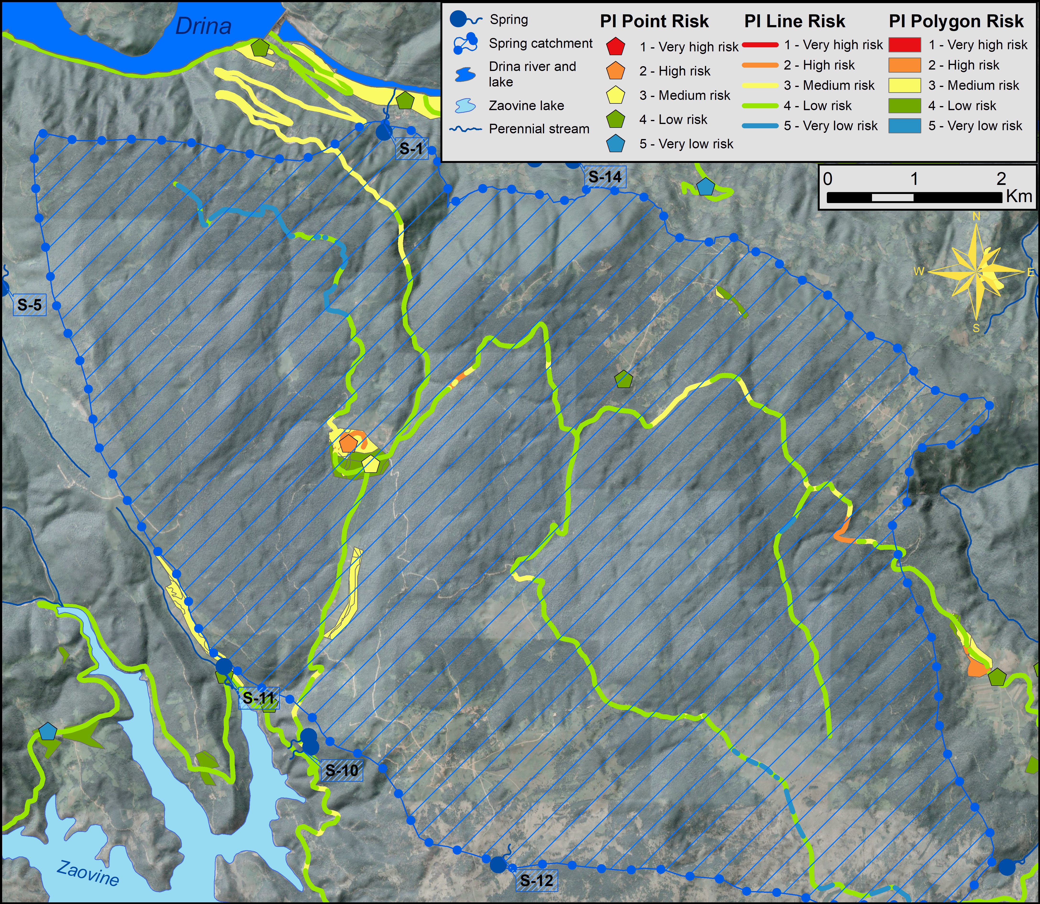
The most appropriate method for groundwater vulnerability assessment was considered in the case study of Tara National park, in Western Serbia. The four commonly used methods were applied to assess the intrinsic vulnerability maps: DRASTIC, EPIK, PI and COP. All the applied methods resulted in different vulnerability maps in assessing the degree of vulnerability, consequently influencing the groundwater contamination risk maps.
The applied research presents an example of how contamination risk should be assessed in a specific area. Comparison of the results obtained for the area of Tara National Park indicates the preference of the PI method as a well-balanced method, taking into account all the specifics of the study area. A detailed analysis of the assessed risks in the catchments of the existing sources was also conducted to indicate probable sources of contamination and confirm the degree of accuracy of the created vulnerability and risk maps. The conducted research emphasizes the necessity to adopt a clear conceptual hydrogeological model and to apply several methods simultaneously to determine the optimal one for each individual area.
Article Details
Issue
Section
Authors have copyright and publishing rights on all published manuscripts.
References
ALLER, L., BENNET, T., LEHR, J., PETTY, R. & HACKETT, G. (1985): DRASTIC: A standardized system for evaluating ground water pollution potential using hydrogeologic settings.– U.S: EPA, Chicago, Illinois.
ANDREO, B., GOLDSHEIDER, N., VADILLO, I., VIAS, J.M., NEUKUM, C., SINREICH, M., JIMENEZ, P., BRECHENMACHER, J., CARRASO, F., HÖTZL, H., PERLE, M.J. & ZWALEN, F. (2006): Karst groundwater protection: First application of a Pan-European Approach to vulnerability, hazard and risk mapping in the Sierra de Libar (Southern Spain).– Sci. Total. Environ., 357, 54–73. doi: 10.1016/j.scitotenv.2005.05.019
BROUYÈRE, S. (2004): A quantitative point of view of the concept of vulnerability.– In: ZWAHLEN, F. (ed.): Vulnerability and risk mapping for the protection of carbonate (karst) aquifers.– Luxembourg: COST Action 620, Office for Official Publications of the European Communities, 10–15.
CORNATON, F., GOLDSCHEIDER, N., JEANNIN, P.Y., PERROCHET, P., POCHON, A., SINREICH, M. & ZWAHLEN, F. (2004): The VULK analytical transport model and mapping method.– In: ZWAHLEN, F. (ed.): Vulnerability and risk mapping for the protection of carbonate (karst) aquifers.– Luxembourg: COST Action 620, Office for Official Publications of the European Communities, 155–160.
DALY, D., DASSARGUES, A., DREW, D., DUNNE, S., GOLDSCHEIDER, N., NEALE, S., POPESCU, I. & ZWAHLEN, F. (2002): Main concepts of the “European approach” to karst-groundwater-vulnerability assessment and mapping.– Hydrogeol. J., 10/2, 340–345. doi:10.1007/s10040-001-0185-1
DOERFLIGER, N. & ZWAHLEN, F. (1997): EPIK: A new method for outlining of protection areas in karstic environment.– In: GÜNAY, G. & JOHNSON, A.I. (eds.): Karst Waters and Environmental Impacts. Balkema, Rotterdam, 117–123.
DREW, D. & DUNNE, S. (2004): Vulnerability mapping for the protection of Karst Aquifers. – In: R & D Technical Report W6-032/TR, Environment Agency England and Wales, Bristol.
DUNN, S. (2004): A Localised European Approach (LEA).– In: ZWAHLEN, F. (ed.): Vulnerability and risk mapping for the protection of carbonate (karst) aquifers.– Luxembourg: COST Action 620, Office for Official Publications of the European Communities, 161–163.
ESRI (2014): ArcGIS Desktop: Release 10.2.– Environmental Systems Research Institute, Redlands CA.
FOSTER, S., HIRATA, R. & ANDREO, B. (2013): The aquifer pollution vulnerability concept: aid or impediment in promoting groundwater protection?– Hydrogeol. J., 21, 1389–1392. doi: 10.1007/s10040-013-1019-7
FOSTER, S., HIRATA, R., GOMES, D., D’ELIA, M. & PARIS, M. (2002): Groundwater Quality Protection, a guide for water utilities, municipal authorities, and environment agencies.– The International Bank for Reconstruction and Development, The World Bank, Washington, USA.
GOGU, R.C. & DASSARGUES, A. (2000): Current trends and future challenges in groundwater vulnerability assessment using overly and index methods.– Environ. Geol., 39, 549–559. doi: 10.1007/s002540050466
GOLDSCHEIDER, N. & POPESCU, C. (2004): The European Approach.– In: ZWAHLEN, F. (ed): Vulnerability and risk mapping for the protection of carbonate (karst) aquifers.– Luxembourg: COST Action 620, Office for Official Publications of the European Communities, 17–21.
GOLDSCHEIDER, N. (2004): The concept of groundwater vulnerability.– In: ZWAHLEN, F. (ed.): Vulnerability and risk mapping for the protection of carbonate (karst) aquifers.– Luxembourg: COST Action 620, Office for Official Publications of the European Communities, 5–9.
GOLDSCHEIDER, N., KLUTE, M., STURM, S. & HÖTZL, H. (2000): The PI method – a GIS-based approach to mapping groundwater vulnerability with special consideration of karst aquifers.– Z. Angew. Geol., 46/3, 157–166.
HOELTING, B., HAERTLÉ, T., HOHBERGER, K.H., NACHTIGALL, K.H., VILLINGER, E., WEINZIERL, W. & WROBEL, J.P. (1995): Konzept zur Ermittlung der Schutzfunktion der Grundwasserueberdeckung.– Geol. Jb., C, 63, 5–24.
HÖTZL, H. (2004): Risk assessment concept.– In: ZWAHLEN, F. (ed): Vulnerability and risk mapping for the protection of carbonate (karst) aquifers.– Luxembourg: COST Action 620, Office for Official Publications of the European Communities, 108–112.
HÖTZL, H., DELPORTE, C., LIESCH, T., MALIK, P., NEUKUM, C. & SVASTA J. (2004): Risk mapping.– In: ZWAHLEN, F. (ed): Vulnerability and risk mapping for the protection of carbonate (karst) aquifers.– Luxembourg: COST Action 620, Office for Official Publications of the European Communities, 113–121.
IVAN, V. & MADL-SZONYI, J. (2017): State of the art of karst vulnerability assessment: overview evaluation and outlook.– Environ. Earth. Sci., 76, 112. doi: 10.1007/s12665-017-6422-2
JEMCOV, I. & PETRIČ, M. (2009): Measured precipitation vs. effective infiltration and their influence on the assessment of karst systems based on results of the time series analysis.– J. Hydrol. 379, 3-4, 304–314. doi: 0.1016/j.jhydrol.2009.10.016
JEMCOV, I. (2014): Estimating potential for exploitation of karst aquifer: case example on two Serbian karst aquifers. Environ Earth Sci. 71, 543–551 doi: 10.1007/s12665-013-2300-8
JEMCOV, I., MILANOVIĆ, S., MILANOVIĆ, P.T., DAŠIĆ, T. (2011): Analysis of the utility and management of karst underground reservoirs: case study of the Perućac karst spring.– Carbonates Evaporites 26, 61–68 (2011). doi: 10.1007/s13146-011-0048-3
JEMCOV, I., ŽIVANOVIĆ, V., ČOLIĆ, S., MILANOVIĆ, S. & TRIVIĆ, B. (2007.): Vulnerability assessment and application of remote sensing - Groundwater resource analysis of National park “Tara”.– In. RIBEIRO, L., CHAMBEL, A. & CONDESSO DE MELO, M.T. (eds.): Proceedings of the XXXV Congress of International Association of Hydrogeologists. Sept. 17–21, 2007. International Association of Hydrogeologists, Lisbon.
JIMÉNEZ-MADRID, A., MARTÍNEZ-NAVARRETE, C. & CARRASCO-CANTOS, F. (2010): Groundwater Risk Intensity Assessment. Application to Carbonate Aquifers of the Western Mediterranean (Southern Spain).– Geodin. Acta, 23, 1–3, 101–111. doi: 10.3166/ga.23.101-111
KETELAERE, D.D., HÖTZL, H., NEUKIM, C., CIVITA, M. & SAPPA, G. (2004): Hazzard analysis and Mapping.– In: ZWAHLEN, F. (ed.): Vulnerability and risk mapping for the protection of carbonate (karst) aquifers.– Luxembourg: COST Action 620, Office for Official Publications of the European Communities, 86–105.
KRALIK, M. & KEIMEL, T. (2003): Time-input, an innovative groundwater vulnerability assessment scheme: application to an alpine test site.– Environ. Geol., 44, 679–686. doi:10.1007/s00254-003-0809-y
KREŠIĆ, N. (1984): Hydrogeology of karst terrains of Drina catchment upstream of Bajina Basta. Serbia.– Unpubl. MS Thesis. University of Belgrade. Faculty of Mining and Geology. Serbia.
MORRIS, B.L. & FOSTER, S.S.D. (2000): Cryptosporidium contamination hazard assessment and risk management for British groundwater sources.– Water Sci. Technol., 41, 7, 67–77. doi: 10.2166/wst.2000.0117
NATIONAL RESEARCH COUNCIL (1993): Ground water vulnerability assessment - Contamination Potential Under Conditions of Uncertainty.– National Academy Press, Washington, USA.
NEUKUM, C. & HÖTZL, H., (2005): Standardisation of vulnerability map.– In: STEVANOVIĆ, Z. & MILANOVIĆ, P. (eds.): Water Resources and Environmental Problems in Karst CVIJIĆ 2005, Belgrade, Faculty of Mining and Geology, 11–19.
NGUYET, V.T.M. & GOLDSCHEIDER, N. (2006): A simplified methodology for mapping groundwater vulnerability and contamination risk, and its first application in a tropical karst area, Vietnam.– Hydrogeol. J., 14, 1666–1675. doi: 10.1007/s10040-006-0069-5
NONER, J.C. (2004): Sources of groundwater contamination.– In: ZAPOROZEC, A. (ed): Groundwater contamination inventory. A methodological guide IHP-VI. Series on Groundwater No. 2. UNESCO OFFICIAL GAZETTE OF THE REPUBLIC OF SERBIA 92/2008 (2008): Rulebook on the method of determining and maintaining the sanitary protection zones of water supply sources.
OLUJUĆ, J. & KAROVIĆ, J. (1985): Osnovna geološka karta SFRJ 1:100000, list Višegrad [Basic Geological Map of SFRY 1:100000, Višegrad Sheet – in Serbian].– Savezni geološki zavod, Beograd.
RAVBAR, N. & GOLDSCHEIDER, N. (2007): Proposed methodology of vulnerability and contamination risk mapping for the protection of karst aquifers in Slovenia.– Acta Carsol., 36/3, 397–411. doi: 10.3986/ac.v36i3.174
SCHMID, S.M., BERNOULLI, D., FÜGENSCHUH, B., MATENCO, L., SCHEFER, S., SCHUSTER, R., TISCHLER, M. & USTASZEWSKI K. (2008): The Alpine Carpathian-Dinaridic orogenic system: correlation and evolution of tectonic units.– Swiss. J. Geosci., 101, 139–183. doi: 10.1007/s00015-008-1247-3
VIAS, J.M., ANDREO, B., PERLES, M.J., CARRASCO, F., VADILLO, I. & JIMENEZ, P. (2006): Proposed method for groundwater vulnerability mapping in carbonate (karstic) aquifers: the COP method.– Hydrogeol. J., 14, 912–925. doi:10.1007/s10040-006-0023-6
VRBA, J. & ZOPOROZEC, A. (eds.) (1994): Guidebook on Mapping Groundwater Vulnerability.– International Contributions to Hydrogeology (IAH), vol 16. IAH, Hannover.
ŽIVANOVIĆ, V., DRAGIŠIĆ, V., ATANACKOVIĆ, N., NINKOVIĆ, S. & NEŠKOVIĆ, D. (2014): Use of GIS in assessment of groundwater contamination risk map – case example of national park Djerdap.– In. CVETKOVIĆ, V. (ed.): XVI Serbian Geological Congress: Proceedings, Donji Milanovac, Srbija, May 22–25, 2014. Serbian Geological Society, 320–325.
ZWAHLEN, F. (2004): Vulnerability and risk mapping for the protection of carbonate (karst) aquifers.– Luxembourg: COST Action 620, Office for Official Publications of the European Communities.