
Preliminary analysis of a LiDAR-based landslide inventory in the area of Samobor, Croatia
Article Sidebar
Main Article Content
Abstract
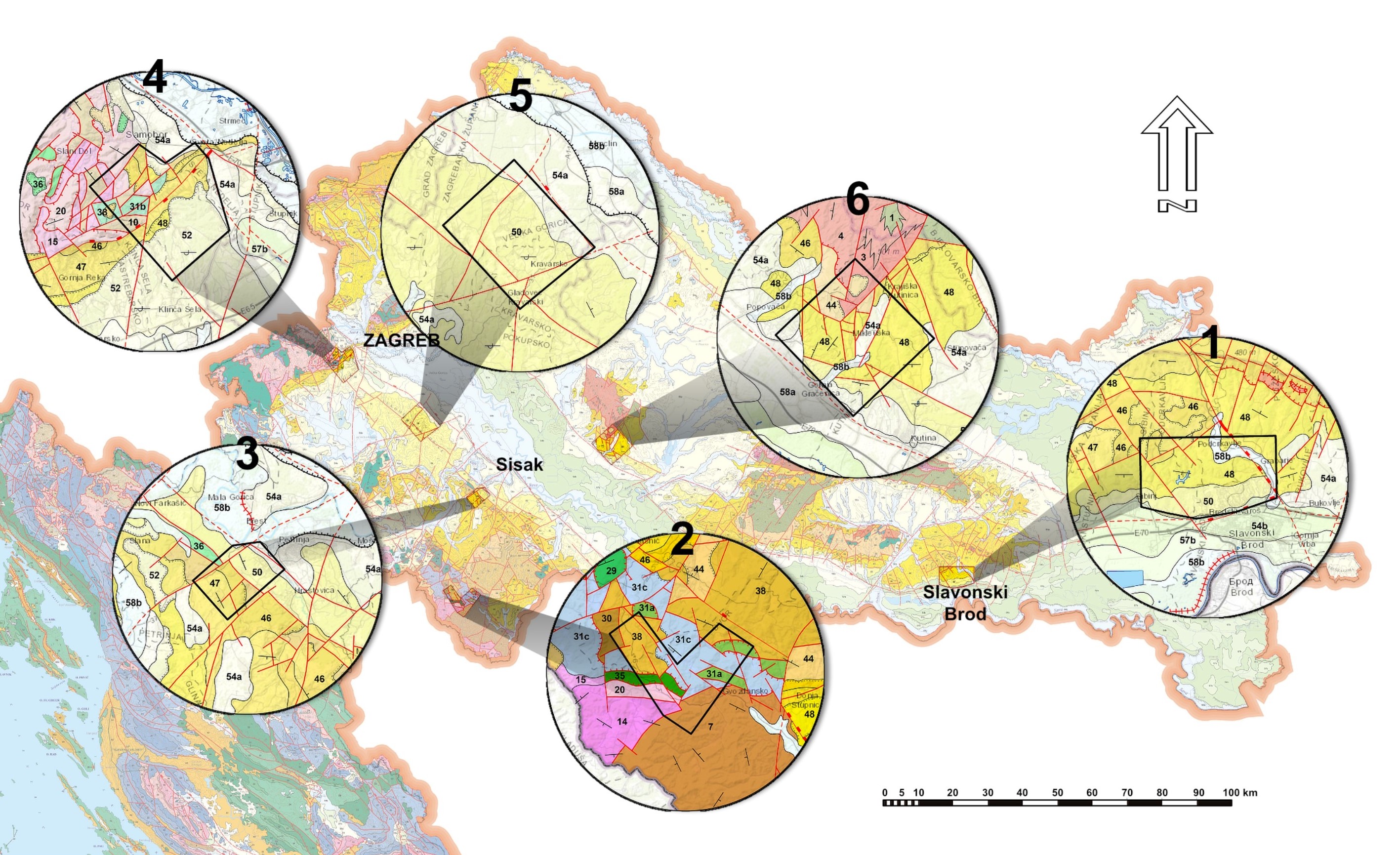
The paper presents an analysis of the LiDAR-based landslide inventory for the area near Samobor, in northwestern Croatia with two main objectives: i) to define the geological units (obtained from Basic Geological Map of Croatia) most susceptible to landslides, and ii) to analyse the limitations of the Basic Geological Map and its applicability in landslide susceptibility map design. Within the study area of 63.8 km2, 874 landslide polygons were manually outlined, covering an area of 2.15 km2. The landslide outline confidence level, landslide index and the relief energy map were used to analyse the landslide susceptibility of a particular geological unit. By that, units in the same state of stress, i.e., in the same relief energy group were compared. This preliminary analysis has shown that the geological units Pl,Q, M3 1,2, and 1M3 1 are the most susceptible to landslides and that older geological units, Pc and K1,2, are also prone to landslides. Still, landslides within those older units can be considered as old and inactive. As for the limitations of the Basic Geological Map of Croatia, three things emerged, namely scale, the geological unit defining approach, and the neglect of regolith. Despite the limitations presented, the usability of the Basic Geological Map of Croatia in the development of small-scale landslide susceptibility maps is emphasized. However, instructions that should attribute engineering geological features to the geological units outlined in the Basic Geological Map should be prepared in the near future.
Article Details
Issue
Section
Authors have copyright and publishing rights on all published manuscripts.
References
ALLABY, A. & ALLABY, M. (2003): A Dictionary of Earth Sciences.– Oxford university press, Oxford, 619 p.
ARDIZZONE, F., CARDINALI, M., GALLI, M., GUZZETTI, F. & REICHENBACH, P. (2007): Identification and mapping of recent rainfall-induced landslides using elevation data collected by airbone Lidar.– Natural Hazards and Earth System Sciences, 7, 637–650. doi: 10.5194/nhess-7-637-2007
BARNES, J.W. & LISLE, R.J. (2004): Basic Geological Mapping.– John Wiley & Sons Ltd, Chichester, 184 p.
BARTELLETTI, C., GIANNECCHINI, R., D’AMATO AVANZI, G., GALANTI, Y. & MAZZALI, A. (2017): The influence of geological–morphological and land use settings on shallow landslides in the Pogliaschina T. basin (northern Apennines, Italy).– Journal of Maps, 13/2, 142–152. doi: 10.1080/17445647.2017.1279082
BELL, R., PETSCHKO, H., RÖHRS, M. & DIX, A. (2012): Assessment of landslide age, landslide persistence and human impact using airborne laser scanning digital terrain models.– Geografiska Annaler: Series A, Physical Geography, 94, 135–156. doi: 10.1111/j.1468‐0459.2012.00454.x
BOSTJANČIĆ, I., FILIPOVIĆ, M., GULAM, V & POLLAK, D. (2021): Regional-Scale Landslide Susceptibility Mapping Using Limited LiDAR-Based Landslide Inventories for Sisak-Moslavina County, Croatia.– Sustainability, 13, 4543. doi: 10.3390/su13084543
BURNS, W.J. & MADIN, I.P. (2009): Protocol for inventory mapping of landslide deposits from Light Detection and Ranging (LIDAR) imagery.– Special paper 42, Oregon Department of Geology and Mineral Industries, 30 p.
CHACON, J., IRIGARAY, C., FERNANDEZ, T. & EL HAMDOUNI, R. (2006): Engineering geology maps: landslides and geographical information systems.– Bulletin of Engineering Geology and the Environment, 65, 341–411. doi: 10.1007/s10064-006-0064-z
CRED, UNISDR (2018): Economic Losses, Poverty & Disasters 1998-2017.– Available at https://www.preventionweb.net/files/61119_credeconomiclosses.pdf [Accesed 20.07.2021.]
ĆIRIĆ, B. (1967): Neotektonska karta SFR Jugoslavije 1:1500000 [Neotectonic map of SFR of Yugoslavia 1:1500000 – in Croatian].– Federal geological institute, Belgrade.
DAI, F.C., LEE, C.F. & NGAI, Y.Y. (2002): Landslide risk assessment and management: an overview.– Engineering Geology 64, 65–87. doi: 10.1016/S0013-7952(01)00093-X
ERSHOV, V.V., NOVIKOV, A.A. & POPOVA, G.B. (1988): Fundamentals of geology.– Mir Publishers, Moscow, 358 p.
FELL, R., COROMINAS, J., BONNARD, C., CASCINI, L., LEROI, E. & SAVAGE, W.Z. (2008): Guidelines for landslide susceptibility, hazard and risk zoning for land use planning.– Engineering geology, 102/3–4, 85–98. doi: 10.1016/j.enggeo.2008.03.022
GUZZETTI, F., CESARE MONDINI, A., CARDINALI, M., FIORUCCI, F., SANTANGELO, M. & CHANG, K.T. (2012): Landslide inventory maps: New tools for an old problem.– Earth-Science Reviews, 112/1–2, 42–66. doi: 10.1016/j.earscirev.2012.02.001
HEĆIMOVIĆ, I. (2009): Klastične naslage (pliokvartar - Pl, Q) [Clastic deposits (Plio Quaternary - Pl, Q), In Croatian]. In: VELIĆ, I. & VLAHOVIĆ, I. (eds.): Tumač Geološke karte Republike Hrvatske 1:300000, Croatian geological survey, Zagreb, 141, 94–95.
HUGGETT, R.J. (2017): Fundamentals of Geomorphology.– Routledge, Abingdon, 579 p.
INDRAWAN, I.G.B., RAHARDJO, H. & LEONG, E.C. (2006): Effects of coarsegrained materials on properties of residual soil.– Engineering Geology, 82, 154–164. doi: 10.1016/j.enggeo.2005.10.003
JABOYEDOFF, M., OPPIKOFER, T., ABELLÁN, A., DERRON, M.-H., LOYE, A., METZGER, R. & PEDRAZZINI, A. (2012): Use of LIDAR in landslide investigations: a review.– Natural Hazards, 61, 5–28. doi: 10.1007/s11069-010-9634-2
JEBUR, M.N., PRADHAN, B. & TEHRANY, M.S. (2014): Optimization of landslide conditioning factors using very high-resolution airborne laser scanning (LiDAR) data at catchment scale.– Remote Sensing of Environment, 152, 150–165. doi: 10.1016/j.rse.2014.05.013
JURAK, V., MATKOVIĆ, I., MIKLIN, Ž. & CVIJANOVIĆ, D. (1998): Landslide hazard in the Medvednica submountain area under dynamic conditions.– In: MARIĆ, B., LISAC, Z. & SZAVITS-NOSSAN, A. (eds.): Geotechnical hazards, XIth Danube-European conference on soil mechanics and geotechnical engineering, Poreč, Croatia.
KEAREY, P. (2001): The new penguin dictionary of geology.– Penguin group, London, 327 p.
LI, Y., CHEN, G., TANG, C., ZHOU, G. & ZHENG, L. (2012): Rainfall and earthquakeinduced landslide susceptibility assessment using GIS and Artificial Neural Network.– Natural Hazards and Earth System Sciences, 12, 2719–2729. doi: 10.5194/nhess-12-2719-2012
LUKIĆ, T., BJELAJAC, D., FITZSIMMONS, K.E., MARKOVIĆ, S.B., BASARIN, B., MLAĐAN, D., MICIĆ, T., SCHAETZL, R.J., GAVRILOV, M.B., MILANOVIĆ, M., SIPOS, G., MEZŐSI, G., KNEŽEVIĆ‑LUKIĆ, N., MILINČIĆ, M., LÉTAL, A. & SAMARDŽIĆ, I. (2018): Factors triggering landslide occurrence on the Zemun loess plateau, Belgrade area, Serbia.– Environmental Earth Sciences, 77, 519. doi: 10.1007/s12665-018-7712-z
MCCALPIN, J. (1984): Preliminary age classification of landslides for inventory mapping.– Proceedings of the Annual Symposium on Engineering Geology and Soil Engineering, 21, Moscow, Idaho, 99–120.
MIHALIĆ, S., OŠTRIĆ, M. & VUJNOVIĆ, T. (2008): Landslide susceptibility mapping in the Starca Basin (Croatia).– Proceedings of 2nd European Conference of International Association for Engineering Geology, 2008, Madrid, Spain.
NOVOSEL-ŠKORIĆ, S., MAGDALNEIĆ, Z. & KOROLIJA, B. (1986): Pliokvartarni sedimeneti jugoistočnog dijela Krndije – Sjeverna Hrvatska [Plioquaternary sediments of the southeastern part of Krndija - Northern Croatia - in Croatian].– Geološki vijesnik, 39, 11–18.
PARK, T.-W., KIM, H.-J., TANVIR, M.T., LEE, J.-B. & MOON, S.-G. (2018): Influence of coarse particles on the physical properties and quic undrained shear strength of fine-grained soils.– Geomechanics and Engineering, 14/1, 99–105. doi: 10.12989/gae.2018.14.1.099
PERKINS, C.R. & PARRY, R.B. (1990): Information Sources in Cartography - Guides to Information Sources.– Bowker-Sour, London.
PIKE (1988): The geometric signature: quantifying landslide - terrain types from digital elevation models.– Mathematical geology, 20/5, 491–511.
REICHENBACH, P., ROSSI, M., MALAMUD, B.D., MIHIR, M. & GUZZETI, F. (2018): A review of statistically-based landslide susceptibility models.– Earth- Science Reviews, 180, 60–91. doi: 10.1016/j.earscirev.2018.03.001
ROSER, M., RITCHIE, H. & ORTIZ-OSPINA, E. (2013): World Population Growth. –Published online at OurWorldInData.org. Retrieved from: ‘https://ourworldindata.org/world-population-growth’ [Accessed 13.07.2021.]
SAVEZNI GEOLOŠKI ZAVOD (1962): Uputstvo za izradu osnovne geološke karte FNRJ [Instructions for making a basic geological map – in Croatian].– Savezni geološki zavod, Beograd, 99 p.
SCHUSTER, R.L. (1996): Socioeconomic significance of landslides. In: TURNER, A.K. & SCHUSTER, R.L. (eds.): Landslides: Investigation and Mitigation.– Special Report 247, Transportation Research Board, National Research Council, National Academy Press, Washington, DC, pp. 12–35.
SHAKOOR, A. & COOK, B.D. (1990): The effect of stone content, size, and shape on the engineering properties of a compacted silty clay.– Environmental and Engineering Geoscience, XXVII/2, 245–253. doi: 10.2113/gseegeosci.xxvii.2.245
SHAN, J. & TOTH, C.K. (2009): Topographic laser ranging and scanning - Principles and processing.– Taylor & Francis Group, LLC, New York, 654 p.
ŠIKIĆ, K. (1995): Prikaz geološke građe Medvednice.– In: ŠIKIĆ, K. (ed.): Geološki vodič Medvednice. Institut za geološka istraživanja, INA-Industrija nafte, Zagreb, 7–30.
ŠIKIĆ, K., BASCH, O. & ŠIMUNIĆ, A. (1977): Osnovna geološka karta RH 1:100000, list Zagreb L38−80 [Basic Geological Map of SFRY 1:100000, Zagreb sheet – in Croatian].– Geološki zavod, Zagreb, Savezni geološki zavod, Beograd.
ŠIKIĆ, K., BASCH, O. & ŠIMUNIĆ, A. (1979): Osnovna geološka karta SFRJ 1:100000. Tumač za list Zagreb L38−80 [Basic Geological Map of SFRY 1:100000, Geology of the Zagreb sheet – in Croatian].– Institut za geološka istraživanja, Zagreb, Savezni geološki zavod, Beograd, 75 p.
UPPAL, S. (2006): Fundamentals of Physical Geography.– National Council of Educational Research and Training, New Delhi, 136 p.
VAN DEN EECKHAUT, M., POESEN, J., VERSTRAETEN, G., VANACKER, V., NYSSEN, J., MOEYERSONS, J., VAN BEEK, L.P.H. & VANDEKERCKHOVE, L. (2007): Use of LIDAR-derived images for mapping old landslides under forest.– Earth Surface Processes and Landforms, 32, 754–769. doi: 10.1002/esp.1417
VARNES, D.J. & IAEG (1984): Landslide hazard zonation: a review of principles and practice.– IAEG Commission on Landslides and Other Mass Movements, Natural Hazards 3, UNESCO, Paris, 63 p.
VRSALJKO, D., PAVELIĆ, D., MIKNIĆ, M., BRKIĆ, M., KOVAČIĆ, M., HEĆIMOVIĆ, I., HAJEK-TADESSE, V., AVANIĆ, R. & KURTANJEK, N. (2006): Middle Miocene (Upper Badenian/Sarmatian) Palaeoecology and Evolution of the Environments in the Area of Medvednica Mt. (North Croatia).– Geologia Croatica, 59/1, 51–63.
VRSALJKO, D., HEĆIMOVIĆ, I. & AVANIĆ, R. (2007): Miocene deposits of Northern Croatia.– In: GRGASOVIĆ, T. & VLAHOVIĆ, I. (eds.): 9th International Symposium on Fossil Algae Croatia, Field Trip Guidebook and Abstracts, Croatian Geological Survey, Zagreb, 143–153.
ZEZERE, J.L., DE BRUM FERREIRA, A. & RODRIGUES, M.L. (1999): The role of conditioning and triggering factors in the occurrence of landslides: a case study in the area north of Lisbon (Portugal).– Geomorphology, 30, 133–146. doi: 10.1016/S0169-555X(99)00050-1