
Geozonation of the Zagreb city area as an input for seismic risk assessment
Article Sidebar
Main Article Content
Abstract
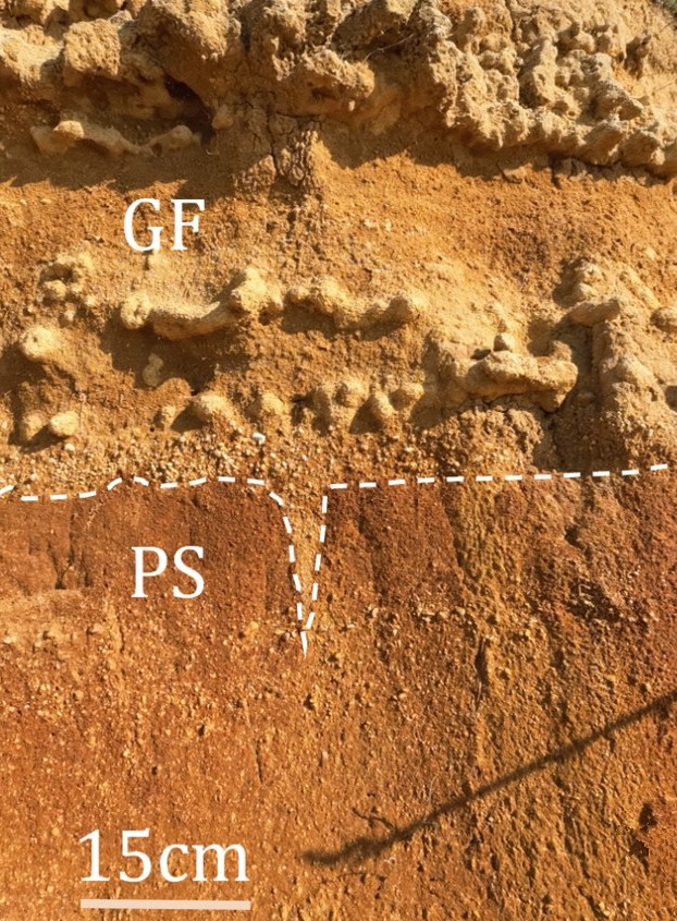
The Zagreb city area is located in a geologically diverse and complex area: on the southern slopes of Medvednica Mountain, the alluvial plains of the Sava River, and on the northern slopes of the Vukomeričke gorice hilly area. The urbanisation of this relatively large area is an ongoing process, and nowadays, the city’s development is proceeding rapidly in unfavourable locations in terms of geohazards, meaning that areas with a possible seismic, flood, or landslide risk are becoming increasingly populated. To achieve sustainable development, geohazards and ground types need to be addressed and assessed for the whole area of Zagreb city as the input for seismic risk assessment. As one step in that direction, existing geological data were reviewed and analysed, and accordingly, geozonation of the Zagreb city area was carried out, differentiating four zones with six geological complexes. Based on the available geological data, we assessed the geohazard processes, ground types, and seismic risk for each differentiated zone and complex, and in that way, a smallscale regional zonation map was developed. Further detailed geo-research of the Zagreb city area is recommended as the city area is relatively large and heterogeneous in terms of geological settings, and detailed geo-data are needed to define local geo-conditions, geohazards, and ground types. With detailed geo-data, the presented geozonation of the Zagreb city area could be upscaled and directly applied in urban planning. The presented results were used as input for the seismic risk assessment for the research area, and the developed regional map is already being used by the local government.
Article Details
Issue
Section

This work is licensed under a Creative Commons Attribution 4.0 International License.
Authors have copyright and publishing rights on all published manuscripts.
References
ALI, S.A., MOHAJANE, M., PARVIN, F., VARASANO, A., HITOURI, S., ŁUPIKASZA, E. & PHAM, Q.B. (2023): Mass movement susceptibility prediction and infrastructural risk assessment (IRA) using GIS-based Meta classification algorithms.– Applied Soft Computing, 145, 110591. https://doi.org/10.1016/j.asoc.2023.110591
BAČIĆ, M. & KADIRI, A. (2020): Estimation of ground motion amplification for the case of Albania earthquake 26th November 2019.– In: Symposium of the PhD studies of the Faculty of Civil Engineering – Croatia. https://doi.org/10.5592/CO/PhDSym.2020.05
BASCH, O. (1980a): Osnovna geološka karta SFRJ 1:100.000, list Ivanić-Grad L33-81 [Basic Geological Map of SFRY 1:100 000, Ivanić-Grad sheet L33-81 – in Croatian].– Institut za geološka istraživanja, Zagreb, Savezni geološki zavod, Beograd.
BASCH, O. (1980b): Osnovna geološka karta SFRJ 1:100.000. Tumač za list Ivanić-Grad L33-81 [Basic Geological Map of SFRY 1:100 000. Explanatory notes for the Ivanić-Grad sheet L33-81 – in Croatian].– Institut za geološka istraživanja, Zagreb, Savezni geološki zavod, Beograd.
BELL, F.G. (2003): Geological Hazards: Their Assessments, Avoidance and Mitigation; E&FN Spon Press: London, UK, 2003; 1–648.
BEROZA, G.C. & KANAMORI, H. (2015): Earthquake Seismology: An Introduction and Overview.– In: SCHUBERT, G. (ed.): Treatise on Geophysics, 2nd edition. Elsevier, 4, 1–150. https://doi.org/10.1016/B978-0-444-53802-4.00069-5
BEŠLIĆ, Ž., KOŽUL, M., ŠARAVANJA, R., ŠOLA, M., PALČIĆ, M. & MUDRONJA, K. (2023): Zagreb u brojkama 2023 [Zagreb in number 2023 – in Croatian]. Grad Zagreb, Gradski ured za gospodarstvo, ekološku održivost i strategijsko planiranje, Sektor za strategijske informacije i istraživanja, Odjel za statističke i analitičke poslove.
BIONDIĆ, B., BRKIĆ, Ž. & BIONDIĆ, R. (2003): Republika Hrvatska – Hidrogeološka karta u Mjerilu 1:300.000 [Republic of Croatia – Hydrogeological Map in scale of 1:300,000 – in Croatian].– Croatian Geological Survey, Zagreb, Croatia.
BOSTJANČIĆ, I., FILIPOVIĆ, M., GULAM, V. & POLLAK, D. (2021): Regional-Scale Landslide susceptibility Mapping Using Limited LiDARBased Landslide Inventories for Sisak-Moslavina County, Croatia.– Sustainability, 13, 4543. https://doi.org/10.3390/su13084543
BRAUN, K. (2002): Republika Hrvatska – Inženjerskogeološka karta u Mjerilu 1:300.000 [Republic of Croatia – Engineering geological Map in scale of 1:300,000 – In Croatian].– Croatian Geological Survey, Zagreb, Croatia.
CEMILOGLU, A., ZHU, L., MOHAMMEDNOUR, A.B., AZARAFZA, M. & NANEHKARAN, Y.A. (2023): Landslide Susceptibility Assessment for Maragheh County, Iran, Using the Logistic Regression Algorithm.– Land, 12, 1397. https://doi.org/10.3390/land12071397
CHACÓN, J., IRIGARAY, C., FERNÁNDEZ, T. & EL HAMDOUNI, R. (2006): Engineering Geology Maps: Landslides and Geographical Information Systems.– Bulletin of Engineering Geology and the Environment, 65, 341–411. https://doi.org/10.1007/s10064-006-0064-z
CHAMINÉ, H.I., CARVALHO, J.M., TEIXEIRA, J. & FREITAS, L. (2015): Role of hydrogeological mapping in groundwater practice: back to basics.– European Geologist, 40, 34–42.
CHAUDHARY, M.T. & PIRACHA, A. (2021): Natural Disasters – Origins, Impacts, Management.– Encyclopedia, 1, 1101–1131. https://doi.org/10.3390/encyclopedia1040084
COMPTON, R.R. (2016): Geology in the Field.– Wiley, Cape Town, South Africa.
CONSTANTINESCU, R., GONZÁLEZ-ZUCCOLOTTO, K., FERRÉS, D., SIERON, K., SIEBE, C., CONNOR, C., CAPRA, L. & TONINI, R. (2022): Probabilistic volcanic hazard assessment at an active but undermonitored volcano: Ceboruco, Mexico.– Journal of Applied Volcanology, 11, 1–20. https://doi.org/10.1186/s13617-022-00119-w
COROMINAS, J., VAN WESTEN, C., FRATTINI, P., CASCINI, L., MALET, J.P., FOTOPOULOU, S., CATANI, F., VAN DEN EECKHAUT, M., MAVROULI, O., AGLIARDI, F., PITILAKIS, K., WINTER, M.G., PASTOR, M., FERLISI, S., TOFANI, V., HERVÁS, J. & SMITH, J.T. (2014): Recommendations for the quantitative analysis of landslide risk.– Bulletin of Engineering Geology and the Environment, 73, 209–263. https://doi.org/10.1007/s10064-013-0538-8
CRANE, J.M. (2013): Effects of stress and water saturation on seismic velocity and attenuation in near surface sediments.– Unpubl. PhD Thesis, Louisiana State University and Agricultural and Mechanical College, Louisiana, USA. https://doi.org/10.31390/gradschool_dissertations.3714
CROATIAN GEOLOGICAL SURVEY (2009a): Geološka karta Republike Hrvatske 1:300.000 [Geological Map of Croatia 1:300,000 – in Croatian].– Croatian Geological Survey, Zagreb, Croatia.
CROATIAN GEOLOGICAL SURVEY (2009b): Tumač geološke karte Republike Hrvatske 1:300.000 [Explanatory notes for the Geological Map of Croatia 1:300,000 – in Croatian].– Croatian Geological Survey, Zagreb, Croatia.
CUERVAS-MONS, J., ZÊZERE, J.L., DOMÍNGUEZ-CUESTA, M.J., BARRA, A., REYES-CARMONA, C., MONSERRAT, O., OLIVEIRA, S.C. & MELO, R. (2022): Assessment of Urban Subsidence in the Lisbon Metropolitan Area (Central-West of Portugal) Applying Sentinel-1 SAR Dataset and Active Deformation Areas Procedure.– Remote Sensing, 14, 4084. https://doi.org/10.3390/rs14164084
ČUBRILOVIĆ, P (1969): Tumač Inženjerskogeološke karte Jugoslavije 1:500.000 [Explanatory notes for Engineering geological Map of Yugoslavia 1:500,000 – in Croatian].– Savezni geološki zavod, Beograd.
ČUBRILOVIĆ, P., PALAVESTRIĆ, L.J. & NIKOLIĆ, T. (1967): Inženjerskogeološka karta Jugoslavije 1:500.000 [Engineering geological Map of Yugoslavia 1:500,000 – in Croatian].– Savezni geološki zavod, Beograd.
DEARMAN, W.R. & FOOKES, P.G. (1974): Engineering geological mapping for civil engineering practice in the United Kingdom.– Quarterly Journal of Engineering Geology, 7, 223–256. https://doi.org/10.1144/GSL.QJEG.1974.007.03.0
DI SALVO, C., CIOTOLI, G., MANCINI, M., NISIO, S. & STIGLIANO, F. (2024): Analysis of Geological Multi-Hazards in an Urban District.– Geosciences, 14, 27. https://doi.org/10.3390/geosciences14020027
DONG, L. & LUO, Q. (2022): Investigations and new insights on earthquake mechanics from fault slip experiments.– Earth Sciende Reviews, 228, 104019. https://doi.org/10.1016/j.earscirev.2022.104019
EL AAL, A.K.A., NABAWY, B.S., AQEEL, A. & ABIDI, A. (2020): Geohazards assessment of the karstified limestone cliffs for safe urban constructions, Sohag, West Nile Valley, Egypt.– Journal of African Earth Sciences, 161, 103671. https://doi.org/10.1016/j.jafrearsci.2019.103671
FERREIRA, T.M. & LOURENÇO, P.B. (2019): Disaster Risk Reduction and Urban Resilience: Concepts, Methods and Applications.– In: FARSANGI, N.E., TAKEWAKI, I., YANG, T., ASTANEH-ASL, A. & GARDONI, P. (eds.): Resilient Structures and Infrastructure. Springer, Singapore. https://doi.org/10.1007/978-981-13-7446-3_17
GALVÁN AGUILAR, E.L. & CHÁVEZ, O.E. (2012): Geological Mapping.– Geology Community Newsletter, 1/1, 4–5.
GONG, W., JUANG, C.H. & WASOWSKI, J. (2021): Geohazards and human settlements: Lessons learned from multiple relocation events in Badong, China – Engineering geologist's perspective.– Engineering Geology, 285, 106051. https://doi.org/10.1016/j.enggeo.2021.106051
GVERIĆ, Z., TOMAŠIĆ, N., DURN, G. & RUBINIĆ, V. (2024): The influence of weathering and pedogenesis on the geochemical record of Miocene marls and Plio-Quaternary sediments, Medvednica Mt., Croatia.– Geologia Croatica, 77, 3, 311–323. https://doi.org/10.4154/gc.2024.17
HART, A.B. & HEARN, G.J. (2018): Mapping geohazards in the watersheds above Leh, Ladakh: The use of publicly-available remote sensing to assist risk management.– International Journal of Disaster Risk Reduction, 31, 789–798. https://doi.org/10.1016/j.ijdrr.2018.07.021
HERAK, M., MIKLIN, Ž., ALLEGRETT, I., DASOVIĆ, I., FIKET, T., HERAK, D., IVANČIĆ, I., KUK, K., KUK, V., MARIĆ, K., MARKUŠIĆ, S., PREVOLNIK, S., PODOLSZKI, L., SOVIĆ, I. & STIPČEVIĆ, J. (2013): Seizmičko i geološko mikrozoniranje prema standardima Eurokoda 8 za zapadni dio podsljemenske urbanizirane zone [Seismic and geological micro zonation according to Eurocode 8 for the western part of Podsljeme urban area – in Croatian].– University of Zagreb, Faculty of Science, Zagreb.
IVKOVIĆ, A. & KOMATINA, M. (1980): Hidrogeološka karta SFRJ 1:500.000 [Hydrogeological Map of SFRY 1:500,000 – in Croatian].– Savezni geološki zavod, Beograd.
IVKOVIĆ, A., ŠARIN, A. & KOMATINA, M. (1983): Tumač za hidrogeološku kartu SFRJ 1:500.000 [Explanatory notes for the Hydrogeological Map of SFRY 1:500,000 – in Croatian].– Savezni geološki zavod, Beograd.
JURAK, V., ORTOLAN, Ž., IVŠIĆ, T., HERAK, M., ŠUMANOVAC, F., VUKELIĆ, I., JUKIĆ, M. & ŠURINA, Z. (2008): Geotehničko i seizmičko mikrozoniranje grada Zagreba – pokušaji i ostvarenje [Geotechnical and seismic microzonation of Zagreb – attempts and realization – in Croatian].– In: Proceedings of the Development of Zagreb City – Croatia 2008.
KAHRAMAN, S. (2019): The Effect of Water Saturation on the P-wave Velocity of Sedimentary Rocks.– In: Proceedings of the 23rd International Congress on Acoustics – Aachen, Germany, 2019.
KUREČIĆ, T., KOVAČIĆ, M. & GRIZELJ, A. (2021): Mineral assemblage and provenance of the pliocene Viviparus beds from the area of Vukomeričke Gorice, Central Croatia.– Geologia Croatica, 74, 3, 253–271. https://doi.org/10.4154/gc.2021.16
LAMELAS, M.T., HOPPE, A., DE LA RIVA, J. & MARINONI, O. (2009): Modelling environmental variables for geohazards and georesources assessment to support sustainable land-use decisions in Zaragoza (Spain).– Geomorphology, 111/1–2, 88–103. https://doi.org/10.1016/j.geomorph.2008.10.021
LEVCHENKO, D.G. (2006): Effect of the water-saturated sediment layer on recording seismic signals with a bottom seismometer.– Oceanology, 46, 739–750. https://doi.org/10.1134/S0001437006050146
LI, S., PENG, L., WANG, X., HUANG, K. & TANG, J. (2023): Do geohazards inhibit urban expansion at the regional scale? Evidence from a counterfactual analysis in Southwest China.– Cities, 142, 104558. https://doi.org/10.1016/j.cities.2023.104558
MARKUŠIĆ, S., STANKO, D., KORBAR, T., BELIĆ, N., PENAVA, D. & KORDIĆ, B. (2020): The Zagreb (Croatia) M5.5 Earthquake on 22 March 2020.– Geosciences, 10, 252. https://doi.org/10.3390/geosciences10070252
MENSAH, J. (2019): Sustainable development: Meaning, history, principles, pillars, and implications for human action: Literature review.– Cogent Social Sciences, 5, 165353. https://doi.org/10.1080/23311886.2019.165353
MIKLIN, Ž., MLINAR, Ž., BRKIĆ, Ž. & HEĆIMOVIĆ, I. (2007): Detaljna inženjerskogeološka karta Podsljemenske urbanizirane zone mjerila 1:5.000 (DIGK-Faza I) [Detailed Engineering–geological Map of Podsljeme Urban Area 1:5000 (Phase I) – in Croatian].– Croatian Geological Survey, Zagreb, Croatia.
MIKLIN, Ž., PODOLSZKI, L., NOVOSEL, T., SOKOLIĆ, Ž., SOKOLIĆ, I., OFAK, J., PADOVAN, B. & ZAILAC, K. (2018): Detaljna inženjerskogeološka karta Podsljemenske urbanizirane zone mjerila 1:5000 (DIGK-Faza II) [Detailed Engineering–geological Map of Podsljeme Urban Area 1:5000 (Phase II) – in Croatian].– Croatian Geological Survey, Zagreb, Croatia.
MIKLIN, Ž., PODOLSZKI, L., NOVOSEL, T., SOKOLIĆ, I., OFAK, J., PADOVAN, B. & SOVIĆ, I. (2019): Studija: Seizmička i geološka mikrozonacija dijela Grada Zagreba [Study: Seismic and geological micro zonation of the part of the City of Zagreb area – in Croatian].– Croatian Geological Survey, Zagreb, Croatia.
MIŠUR, I., BALEN, D., KLÖTZLI, U., BELAK, M., MASSONE, H.-J., BRLEK, M. & BRČIĆ, V. (2023): Petrochronological study of chloritoid schist from Medvednica Mountain (Zagorje Mid-Transdanubian zone, Croatia).– Geologia Croatica, 76/1, 13–36. https://doi.org/10.4154/gc.2023.02
PADOVAN, B., PODOLSZKI, L., SOKOLIĆ, I., SOVIĆ, I., NOVOSEL, T., PIVČEVIĆ, N. & KOSOVIĆ, I. (2021): Seismic and geological zonation of the part of the City of Zagreb area.– In: LAKUŠIĆ, S. & ATALIĆ, J. (eds.): Proceedings of the 1st Croatian Conference on Earthquake Engineering 1CroCEE 2021 – Croatia, 2021. https://doi.org/10.5592/CO/1CroCEE.2021.26
PIKIJA, M. (1987): Osnovna Geološka Karta SFRJ 1:100.000, list Sisak L 33-93 [Basic Geological Map of SFRY 1:100,000, Sisak sheet L 33-93 – in Croatian].– Savezni geološki zavod, Beograd.
PODOLSZKI, L. & KARLOVIĆ, I. (2023): Remote Sensing and GIS in Landslide Management: An Example from the Kravarsko Area, Croatia.– Remote Sensing, 15, 5519. https://doi.org/10.3390/rs15235519
PODOLSZKI, L. & TERZIĆ, J. (2023): Procjena potresnog rizika grada Zagreba – Geološki elaborat [Zagreb city seismic risk assessment – Geo logical report – in Croatian].– Croatian Geological Survey, Zagreb, Croatia.
PODOLSZKI, L., MIKLIN, L., KOSOVIĆ, I. & GULAM, V. (2023a): Multi-Level Data Analyses in the Gajevo Landslide Research, Croatia.– Remote Sensing, 15, 200. https://doi.org/10.3390/rs15010200
PODOLSZKI, L., POLLAK, D., FRANGEN, T. & KOSOVIĆ, I. (2023b): What we could learn from Petrinja 2020 earthquake coseismic ground failures?– In: Proceedings of the 9th Conference of Croatian Geotechnical Society – Croatia 2023.
POLLAK, D., GULAM, V., NOVOSEL, T., AVANIĆ, R., TOMLJENOVIĆ, B., HEĆEJ, N., TERZIĆ, J., STIPČEVIĆ, J., BAČIĆ, M., KUREČIĆ, T., DOLIĆ, M., BOSTJANČIĆ, I., WACHA, L., KOSOVIĆ, I., BUDIĆ, M., VUKOVSKI, M., BELIĆ, N., ŠPELIĆ, M., BRČIĆ, V., BARBAČA, J., KORDIĆ, B., PALENIK, D., FILJAK, R., FRANGEN, T., PAVIĆ, M., URUMOVIĆ, K., SEČANJ, M., MATOŠ, B., GOVORČIN, M., KOVAČEVIĆ, M.S. & LIBRIĆ, L. (2021): The preliminary inventory of coseismic ground failures related to December 2020 – January 2021 Petrinja earthquake series.– Geologia Croatica, 74, 2, 189–208. https://doi.org/10.4154/gc.2021.08
PRICE, D.G. (2009): Engineering geology – Principles and Practice.– Springer, Berlin, Germany.
RAHMAN, R.M., SHI, Z.H. & CHONGFA, C. (2009): Soil erosion hazard evaluation – An integrated use of remote sensing, GIS and statistical approaches with biophysical parameters towards management strategies.– Ecological Modelling, 220, 13–14, 1724–1734. https://doi.org/10.1016/j.ecolmodel.2009.04.004
SALE, D. & EL KAWY, A.A. (2021): Problematic soil risk assessment approach for sustainable spatial suitability of urban land use in new cities by using GIS and remote sensing: A case study of new east port said city.– International Journal of Sustainable Development and Planning, 16, 4, 615–628. https://doi.org/10.18280/ijsdp.160402
SEVILLE, E. & METCALFE, J. (2005): Developing Hazard Risk Assessment Framework for the New Zealand State Highway Network.– Land Transport New Zealand Research Report, 276, 1–80.
SLOVENEC, D., HALAMIĆ, J. & ŠEGVIĆ, B. (2024): Middle Triassic basaltic pyroclastic rocks from the Mt. Medvednica ophiolitic mélange (NW Croatia): petrology, geochemistry and tectono-magmatic setting.– Geologia Croatica, 77, 2, 57–68. https://doi.org/10.4154/gc.2024.06
STRUCKMEIER, W.F. & MARGAT, J. (1995): Hydrogeological Maps – A guide and a standard legend.– International Association of Hydrogeologists, Hannover, Germany.
ŠIKIĆ, K., BASCH, O. & ŠIMUNIĆ, A. (1978): Osnovna geološka karta SFRJ 1:100.000, list Zagreb L 33-80 [Basic Geological Map of SFRY 1:100 000, Zagreb sheet L 33-80 – in Croatian].– Institut za geološka istraživanja, Zagreb, Savezni geološki zavod, Beograd.
ŠIKIĆ, K., BASCH, O. & ŠIMUNIĆ, A. (1979): Osnovna geološka karta SFRJ 1:100 000. Tumač za list Zagreb L 33-80 [Basic Geological Map of SFRY 1:100 000. Explanatory notes for the Zagreb sheet L 33-80 – in Croatian]. Institut za geološka istraživanja, Zagreb, Savezni geološki zavod, Beograd.
TEIXEIRA, J., CHAMINÉ, H.I., CARVALHO, J.M., PÉREZ-ALBERTI, A. & ROCHA, F. (2013): Hydrogeomorphological mapping as a tool in groundwater exploration.– Journal of Maps, 9, 2, 263–273. https://doi.org/10.1080/17445647.2013.776506
TOKSÖZ, M.N., CHENG, C.H. & TIMUR, A. (1976): Velocities of seismic waves in porous rocks.– Geophysics, 41, 621–645. https://doi.org/10.1190/1.1440639
TWISDALE, L.A. & VICKERY, P.J. (1995): Extreme-Wind Risk Assessment.– In: SUNDARARAJAN, C. (ed): Probabilistic Structural Mechanics Handbook. Springer, Boston, USA. https://doi.org/10.1007/978-1-4615-1771-9_20
UNIVERSITY OF ZAGREB (2024): Seizmološki pojmovnik [Seismic glossary – in Croatian].– University of Zagreb, Faculty of Science.
VAMVAKARIS, D.A., PAPAZACHOS, C.B., PAPAIOANNOU, C.A., SCORDILIS, E.M. & KARAKAISIS, G.F. (2016): A detailed seismic zonation model for shallow earthquakes in the broader Aegean area.– Natural Hazards and Earth Systems Sciences, 16, 55–84. https://doi.org/10.5194/nhess-16-55-2016
VARNES, D.J. (1974): The Logic of Geological Maps, with Reference to Their Interpretation and Use for Engineering Purposes.– USGS Professional Paper, 837, Alexandria, USA.
YANG, L. (2023): Sustainable City Planning and Development: Transport and Land Use.–Sustainability, 15, 15804. https://doi.org/10.3390/su152215804
ZACCAGNINO, D. & DOGLIONI, C. (2022): The impact of faulting complexity and type on earthquake rupture dynamics.– Communications Earth & Environment, 3, 258, 1–10. https://doi.org/10.1038/s43247-022-00593-5
ZHOU, X., WU, W., LIN, Z., ZHANG, G., CHEN, R., SONG, Y., WANG, Z., LANG, T., QIN, Y., OU, P., HUANGFU, W., ZHANG, Y., XIE, L., HUANG, X., FU, X., LI, J., JIANG, J., ZHANG, M., LIU, Y., PENG, S., SHAO, C., BAI, Y., ZHANG, X., LIU, X. & LIU, W. (2021): Zonation of Landslide Susceptibility in Ruijin, Jiangxi, China.– International Journal of Environmental Research and Public Health, 18, 5906. https://doi.org/10.3390/ijerph18115906
Web source:
EN 1998-1:2004 (2005): Eurocode 8: Design of structures for earthquake resistance – Part 1: General rules, seismic actions and rules for buildings.– European Commission, Bruxelles, Belgium. Available at: https://eurocodes.jrc.ec.europa.eu/EN-Eurocodes/eurocode-8-design-structures-earth-quake-resistance. Accessed on: February 3rd, 2024.