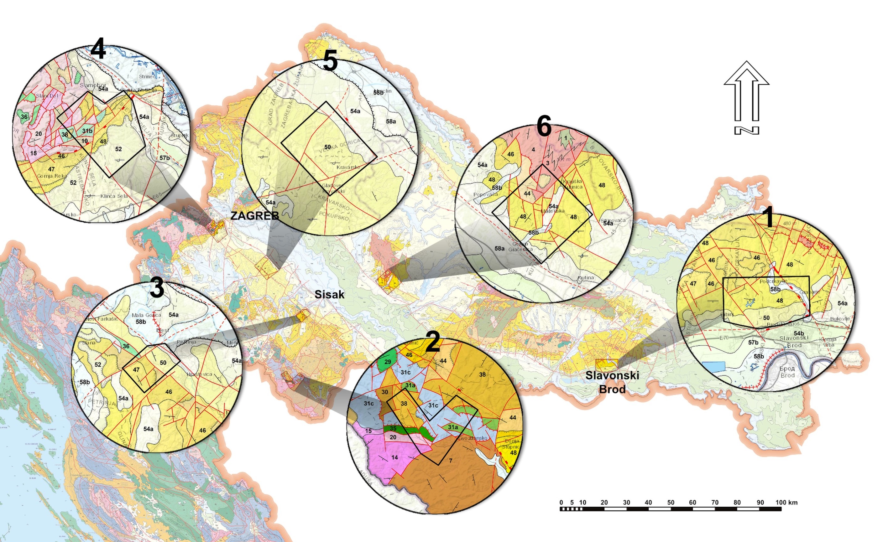
Spatial distribution of the study polygons on the geological map of the Republic of Croatia M 1: 300.000 (HGI, 2009) – for more information see the papers by BOSTJANČIĆ et al. – polygon 1, FILIPOVIĆ et al. – polygon 2, FRANGEN et al. – polygon 3, GULAM et al. – polygon 4, PODOLSZKI et al. – polygon 5 and POLLAK et al. – polygon 6 (this Vol.)

Published: 2022-01-31

Preliminary analysis of a LiDAR-based landslide inventory in the area of Samobor, Croatia

Vlatko Gulam, Iris Bostjančić, Nina Hećej, Marina Filipovic, Radovan Filjak

51-66

Remote landslide mapping, field validation and model development – An example from Kravarsko, Croatia

Laszlo Podolszki, Tomislav Kurečić, Luke Bateson, Kristian Svennevig

67-82

A sedimentological description of the Middle Triassic vertebrate-bearing limestone from Velika planina, the Kamnik-Savinja Alps, Slovenia

Luka Gale, Tomaž Hitij, Blaž Vičič, Matija Križnar, Jure Žalohar, Bogomir Celarc, Marko Vrabec

101-113

The radiolarian age and petrographic composition of a block of the Lower Jurassic volcaniclastic breccia and chert of the Mamonia Complex, SW Cyprus

Nikita Bragin, Galina Ledneva, Liubov Bragina, Efthymios Tsiolakis, Vasilis Symeou, Nikolaos Papadimitriou

115-128

The contribution of geochemical and mineralogical characterization of iron slags in provenance studies in the Podravina region, NE Croatia

Tomislav Brenko, Tena Karavidović, Sibila Borojević Šoštarić, Tajana Sekelj Ivančan

165-176

Sorption of cadmium, zinc and copper in dominant soils of the Zagreb aquifer system, Croatia

Zoran Kovač, Stanko Ružičić, Vedran Rubinić, Zoran Nakić, Marcel Sertić

177-188